Current location: Chillicothe, OH
Current weather: Sunny 69
Miles traveled today: 459.2
Total miles traveled: 1,351.7
Today we left Fayetteville, NC, around 8am and instead of taking the interstate through Raleigh we took a back highway. I was thinking at first that we should have just kept with the regular route, but I think it's fun to switch it up a little. Traveling through the "boonies" of NC was in fact fairly interesting. Cotton planting season is now in full swing, and we also noticed numerous small grave yards right along the roads. It was almost as if the people that lived in the house were just buried out in their front yard by their favorite tree....very interesting indeed.

I also love how much the land changes while you're in NC. We started out with flat sandy soil and in a few hours we are greeted with our first sign of the Appalachian Mountains. Mt. Pilot was always a fun landmark for me when I was a kid heading out to the outer banks, not only did it signify the entrance into NC, but also the unique shape of the mountain. When I was little I always called it Mt. Burt in honor of Burt from Sesame Street. Then when I got older and traveling with some of my guy friends we renamed it Mt. Boob. Looking at it now I think Mt. Burt is a much better name, and it always makes me happy to see it.
*******SCIENCE NERD ALERT********** When we started driving up the mountains we noticed a water bottle we had in the truck was dripping every time we would climb up the mountain. When we would level out it would stop, and when we were descending the mountain the water would actually retreat back down the straw into the bottle. Hopefully the video works!

Once we got into Virginia we decided to stop at a historic site along the interstate. We stopped at Shot Tower State Park only to find out they don't open until April 1, go figure. We did however get a picture of the tower and I read about what it was used for. I found out that this tower was used to make lead shot for the civil war. Lead and firewood were taken to the top of the tower and the lead was melted down. The molten lead was then dropped down pipes of different sizes and the lead fell over 150 feet, most of it being underground. As the lead fell not only did it cool but it also took on a spherical shape. The lead then fell gently into a large pot of water to cool down even further.
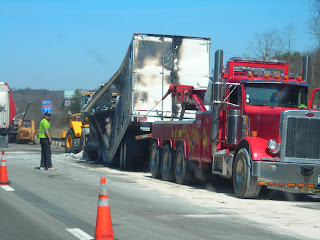
We then ran into our first traffic jam/wreck of the trips. I think by the time we got there most of the carnage was cleaned up. The only thing we could see was the remnants of a semi trailer that had caught fire. I just hope everyone was ok.
Tomorrow we have about 5 hours ahead of us, and I'm looking forward to being back home for a few days and spending time with Lacey's family for Easter before we head out to Iowa.
Next up.....The Holy Land (West Lafayette, IN)


No comments:
Post a Comment